West Yellowstone Maps and Orientation
(West Yellowstone, Montana - MT, USA)
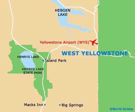
A small town in Montana, West Yellowstone lies within Gallatin County and next to Highway US-20 (Targhee Pass Highway). Yellowstone Airport is just a short distance to the northwest and can be reach along the Gallatin Road / Canyon Street, while directly to the east is the vast
Yellowstone National Park and its many geysers.
Often described as a small and remote mountain town with an unmistakable rustic charm, West Yellowstone also stands next to National Forest lands and to the southeast of the
Hebgen Lake. Currently, the total population stands at just 1,500 residents, although this number quickly swells during the summer months, when tourists converge here in large numbers.
Maps and Orientation of the Region
Maps of the Yellowstone National Park are necessary if you are planning to find your way around and a number of helpful visitors centers are scattered around the park itself. Do bear in mind that whilst the park remains open throughout the year, some of the entrances and roads will be closed during the winter months, when snowfall is likely.
- Ashton (Idaho) - 55 miles / 89 km (one hour and ten minutes, south)
- Bozeman - 88 miles / 142 km (one hour and 50 minutes, north)
- Dillon - 135 miles / 217 km (two hours and 30 minutes, northwest)
- Ennis - 71 miles / 114 km (one hour and 15 minutes, northwest)
- Gardiner - 54 miles / 87 km (one hour and 30 minutes, northeast)
- Grand Teton National Park (Wyoming) - 96 miles / 154 km (two hours and 25 minutes, southeast)
- Idaho Falls (Idaho) - 108 miles / 174 km (one hour and 55 minutes, southwest)
- Island Park (Idaho) - 28 miles / 45 km (35 minutes, southwest)
- Jackson Hole (Wyoming) - 126 miles / 203 km (three hours, south)
- Rexburg (Idaho) - 83 miles / 134 km (one hour and 30 minutes, southwest)
- Salt Lake City (Utah) - 320 miles / 515 km (five hours, south)
- St. Anthony (Idaho) - 69 miles / 111 km (one hour and 15 minutes, southwest)
- Sheridan - 105 miles / 169 km (two hours, northwest)
- Sugar City (Idaho) - 77 miles / 124 km (one hour and 25 minutes, southwest)
- Tetonia (Idaho) - 86 miles / 138 km (one hour and 50 minutes, south)
Map of the United States

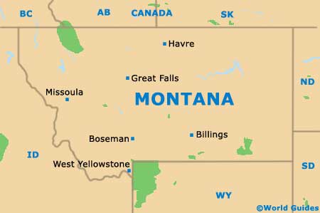
Map of Montana
Map of West Yellowstone